politics
Satellite Images Reveal Changes in La Guaira Following Twin Earthquakes
26 Haziran 2026Al Jazeera
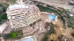
- Satellite images reveal the significant changes in Venezuela's coastal city of La Guaira following the recent twin earthquakes. The visuals highlight the destruction and impact on infrastructure caused by the seismic events.
- This comparison underscores the vulnerability of coastal regions to natural disasters and the urgent need for disaster preparedness.
- Venezuela has faced numerous challenges, including economic instability and political unrest, which complicate disaster response efforts. The recent earthquakes add another layer of difficulty for the region, highlighting the importance of international aid and support in recovery efforts.
- The satellite imagery serves as a stark reminder of the destructive power of earthquakes, particularly in densely populated coastal areas like La Guaira. The visual evidence of damage can influence both public perception and governmental response to disaster management.
NewsAI özeti
This article is based on satellite imagery and does not provide detailed ground-level assessments of the damage.
Orijinal Kaynak
Tam teknik rapor ve canlı veriler için yayıncının web sitesini ziyaret edin.
Kaynağı Görüntüleİlgili Haberler
Tümünü Gör

NewsAI Mobil Uygulamaları
Her yerde okuyun. iOS ve Android için ödüllü uygulamalarımızı indirin.